Noise Mapping of road infrastructures under the responsibility of the Municipality of Mantua
The Noise Mapping of the Municipality of Mantua concerned municipal road infrastructures characterised by traffic volumes exceeding 3 million vehicles per year, identified by legislation as “major roads” pursuant to Legislative Decree 194/2005 and subsequent amendments and additions. This activity forms part of the obligations established by European and national environmental noise legislation, aimed at preventing and reducing the harmful effects of prolonged noise exposure on urban population and sensitive receptors through systematic monitoring and strategic environmental planning measures.
The City of Mantua , a provincial capital located in the south-eastern part of the Lombardy Region, is characterised by highly urbanised areas. The Municipality of Mantova has a population of 48’755 inhabitants (source: ISTAT 2021) and covers an area of 63.81 kmq.
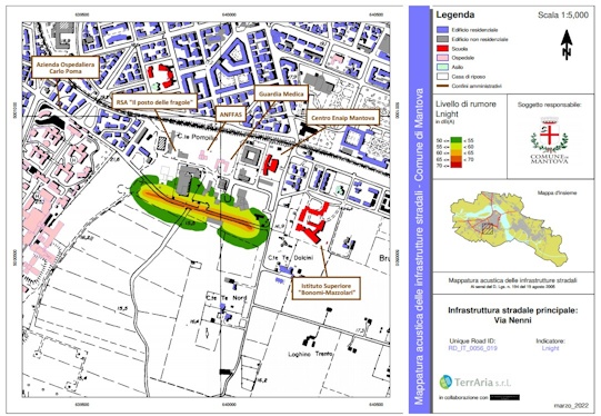
The Noise Mapping of road infrastructures aims to assess population exposure to traffic noise along the main urban arteries, providing an updated knowledge framework on traffic noise pollution to support municipal planning and public health protection policies within the scope of local administrative competences, with particular reference to the temporal variability of traffic flows and differences in exposure between daytime and night-time periods in residential urban areas. Specifically, the Noise Mapping of the Municipality of Mantova covers 22 road infrastructures with a strategic role in urban mobility.
The identification of the infrastructures under study was carried out through an analysis of traffic flows, selecting roads with an Annual Average Daily Traffic exceeding the regulatory threshold. For each road infrastructure, emission characteristics were estimated in terms of hourly traffic flows and travel speeds, using data from automatic traffic monitoring campaigns and fixed instrumentation. The collected data were subsequently aggregated according to vehicle categories and time periods defined by the European CNOSSOS-EU methodology.
The Noise Mapping of road infrastructures in the Municipality of Mantua was carried out using the SoundPLAN software, which enables simulation of noise propagation generated by vehicular traffic and the production of detailed spatially referenced thematic maps of noise contour levels. The modelling analyses made it possible to represent the acoustic impact of municipal road infrastructures and to identify the areas most exposed to traffic noise pollution, with particular attention to sensitive receptors such as schools and healthcare facilities.
Based on the environmental indicators Lden and Lnight, population exposure data to different noise levels were processed within a GIS environment, providing useful information for defining intervention priorities. The study framework promotes integrated environmental assessment by combining traffic monitoring data, acoustic simulation techniques and spatial analysis tools.
The project enabled the Municipality of Mantua to acquire an updated knowledge base on urban traffic noise pollution, supporting the subsequent preparation of Noise Action Plans and sustainable mobility strategies. The integration of traffic flow analysis, acoustic modelling and geographic information systems facilitated a territorial interpretation of noise exposure, promoting a targeted approach to managing environmental criticalities with a view to improving urban acoustic conditions.
The information layers were transmitted to the Ministry in compliance with the formats, timelines and procedural requirements set out in the Reporting Mechanisms provided for by Directive 2001/49/EC and were made available to the European Commission.
THE ROLE OF TERRARIA
The company supported the Municipality of Mantua throughout the entire Noise Mapping process, overseeing—together with an acoustic consultancy firm—the traffic flows analysis, noise modelling and cartographic processing within a GIS environment. Through the use of specialist tools and methodologies compliant with European standards, the company provided technical and scientific support aimed at assessing the acoustic impact of municipal road infrastructures and establishing a solid basis for planning noise mitigation interventions with a view to improving public health.