Application of a High-Resolution Air Quality Model for Epidemiological Analysis
The project concerns the application of a high-resolution air quality model over the Municipality of Milan and surrounding municipalities, with specific reference to the territory of the Milan health and social care district. The objective is to reconstruct the spatial distribution of pollutants in the urban environment in order to support population exposure analyses and the assessment of air pollution impacts on public health.
The study covers the five-year period 2015–2019 and provides the scientific basis for environmental epidemiology analyses conducted by ATS (health protection agency) Milano. Within this project, the UTAQ (Urban Tool for Air Quality) tool is used, an air quality model developed by TerrAria for forecasting and reconstructing air quality in Milan at high urban resolution.
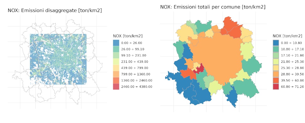
The adopted approach enables highly detailed spatial representation of pollutant concentrations in the urban environment, integrating the main emission sources – including traffic, residential heating, industrial activities and other emission sectors – together with the regional background contribution derived from the European EMEP (European Monitoring and Evaluation Programme) model.
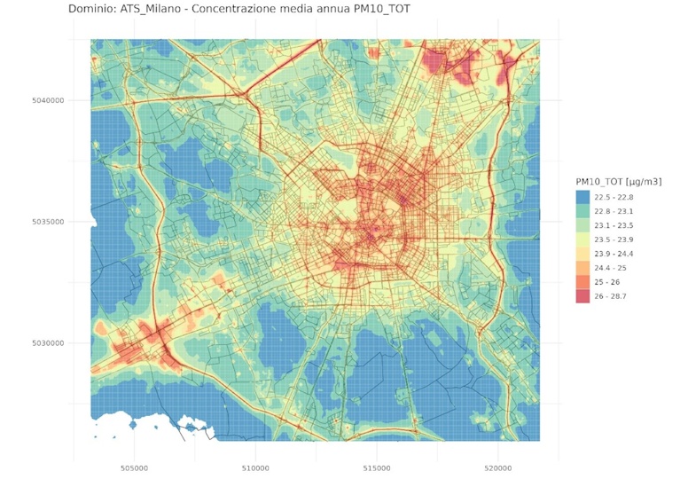
The UTAQ system, applied to a 20×20 km computational domain covering the Municipality of Milan and neighbouring municipalities, produces high-resolution (25 m) air quality maps for the main pollutants of interest, including PM10, PM2.5 and NO₂.
The UTAQ model can be used both in diagnostic mode, for analysing the current situation and assessing alternative scenarios, and in forecasting mode, with horizons of up to four days. For the assessment of impacts within the Milan health and social care district, UTAQ was applied in diagnostic mode in an “advanced” configuration: simulations were not limited to analysing only the traffic component (the focus of the first version of the tool), but extended to all emission components present in the study area. This enables citizens, technical experts and epidemiologists to access detailed information on pollutant distribution in the urban environment, including on the basis of individual location (for example via GPS), thereby making it possible to estimate personal exposure and identify areas of greater public health concern. At the same time, the system supports spatial planners and public decision-makers in the ex-ante evaluation of the effects of traffic and emission control measures (reduction of vehicle flows, restriction of heavy-duty vehicles, establishment of Low Emission Zones, etc.) on achieving compliance with regulatory air quality standards.
Model validation was performed by comparing simulation outputs with data from the ARPA Lombardia monitoring network stations, showing good agreement between simulated and observed values.
The main results for Milan’s air quality in 2019 indicate:
- PM10: most of the analysed territory is subject to numerous exceedances of the daily limit value of 50 µg/m³, while no exceedances of the annual limit value of 40 µg/m³ were identified. The maximum local contribution (sum of emission sectors) reaches approximately 22%, with contributions of up to 19% from traffic, 16% from residential sources and 18% from industry, while the regional background contribution remains predominant.
- PM2.5: the territory is widely affected by exceedances of the annual limit value of 25 µg/m³. Emission sector contributions are distributed among traffic (17%), residential sources (17%) and industry (13%), with a significant share attributable to the regional background.
- NO₂: the model identifies numerous exceedances of the annual limit value of 40 µg/m³, often confirmed by observed data. In this case, the main contribution is linked to traffic (approximately 60%), followed by the industrial sector (approximately 32%), while the regional background plays a more marginal role.
THE ROLE OF TERRARIA
TerrAria contributed to the project by providing the internally developed UTAQ air quality model and overseeing its application to the territorial context of Milan and neighbouring municipalities. The contribution included configuration of the computational domain, integration of the various emission sources and the European EMEP background, execution of simulations for the 2015–2019 period, and validation of results against data from the regional monitoring network. This technological and modelling support enabled the production of a high-resolution representation of pollutant distribution in the urban environment, providing a solid scientific basis for assessing the public health impacts of air pollution and for supporting environmental and health planning decisions.