High-Resolution Assessment of Population Exposure to Air Pollutants
In the health and social care district of Cremona, which includes 47 municipalities within the province, an air quality simulation modelling study was carried out using the UTAQ (Urban Tool for Air Quality) tool developed by TerrAria. This air quality simulation system, designed to operate at the urban scale with high spatial resolution, enabled ATS (health protection agency) Val Padana to obtain detailed maps of population exposure to the main pollutants over the 2007–2019 period. These maps were used to assess the health effects of air pollution on residents of Cremona and neighbouring municipalities. The simulation domain, with a 50 m resolution and an overall extent of 51 km × 37 km, made it possible to describe spatial variations in pollutant concentrations across the territory with a high level of detail.
For this study, all major emission sectors present in the Cremona area were included in the air quality simulations (transport, residential heating, industry and other sources), in order to represent the sources responsible for population exposure to pollutants. The atmospheric background was reconstructed using estimates from the European EMEP model. Local emissions were derived from official inventories (INEMAR for Lombardy and regional databases for Emilia-Romagna), adapted to the different simulation years. The simulations were subsequently validated by comparing model outputs with measurements from ARPA Lombardia and ARPA Emilia-Romagna monitoring stations.
The modelling results for 2019 show:
- PM10: consistent with ARPA monitoring station measurements, most of the territory is affected by frequent exceedances of the daily limit value of 50 µg/m³, while no exceedances of the annual mean limit value of 40 µg/m³ were observed. The maximum local contribution (sum of the main emission sectors) reaches approximately 36%, with contributions of up to 36% from traffic, 15% from the residential sector and 12% from industry. However, the dominant share of concentrations is attributable to the regional background, which includes both the Po Valley background and secondary particulate formation.
- PM2.5: a significant portion of the territory is exposed to concentrations above the annual limit value of 25 µg/m³. Sectoral contributions amount to approximately 26% from traffic, 20% from residential sources and 6% from industry, with a largely prevailing share once again attributable to the regional background.
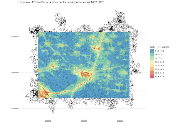
- NO₂: the model identifies only two areas exceeding the annual limit value of 40 µg/m³, in agreement with observed data. In this case, the local component is dominant, with traffic contributing up to 82% and the industrial sector up to 34%, while the regional background plays a secondary role compared to what is observed for fine particulate matter.
In the Cremona area, fine particulate matter is strongly influenced by the regional context, whereas NO₂ is dominated by local emissions, particularly vehicular traffic. A similar analysis conducted for 2017, using a different background reconstruction (CAMx model), produced very similar results in terms of limit exceedances and distribution of emission sources.
The project enabled the development of a historical mapping of population exposure to pollutants, forming the basis for environmental epidemiology studies and operating at a much finer resolution than that achievable with conventional atmospheric dispersion models and monitoring stations alone.
THE ROLE OF TERRARIA
The company contributed to the development and operational adaptation of the UTAQ model for the Cremona district context, integrating emission data, background models and validation procedures with official monitoring networks. This made it possible to apply an advanced air quality simulation tool for Cremona in support of ATS Val Padana analyses and environmental epidemiology studies in the area, enabling a comprehensive assessment of population exposure to air pollutants.