Regional modelling and local modelling for Jazan Economic City (Saudi Arabia)
MARS – Multimodel AiR Suite is the platform developed by TerrAria to integrate, automate and make reproducible modelling chains dedicated to air quality. The MARS system was developed in collaboration with Wood in the context of “Environmental services for Jazan City, primary and downstream industries: environmental studies, surveys and assessment” for Kingdom of Saudi Arabia’s Royal Commission for Jubail and Yanbu.
The suite enables the integration of meteorological and dispersion models across multiple spatial scales, standardizing configurations, emission inputs and outputs, and providing a unified operational environment for running simulations, analyzing results and visualizing outputs.
Within the framework of an international Environmental Impact Assessment (EIA) aimed at the environmental impacts evaluation associated with the large industrial hub of Jazan Economic City, in south-western Saudi Arabia, TerrAria participated—on behalf of Wood—in the development of an integrated modelling system designed to comprehensively describe air quality across a very large area characterized by heterogeneous emission sources, complex atmospheric dynamics and rapidly evolving industrial development scenarios. The objective was to provide local authorities with a robust, reliable and easily updatable tool capable of simulating both the behavior of the regional atmospheric context and the impact of individual industrial and infrastructure sources within and around the Jazan City for Primary and Downstream Industries (JCPDI).
To address the wide range of phenomena involved, the study included the combined application of the CAMx and CALPUFF models, integrated within a meteorological modelling chain based on WRF and CALMET. The regional scale was investigated using CAMx, an Eulerian photochemical model widely used internationally to simulate the formation and transformation of secondary pollutants.
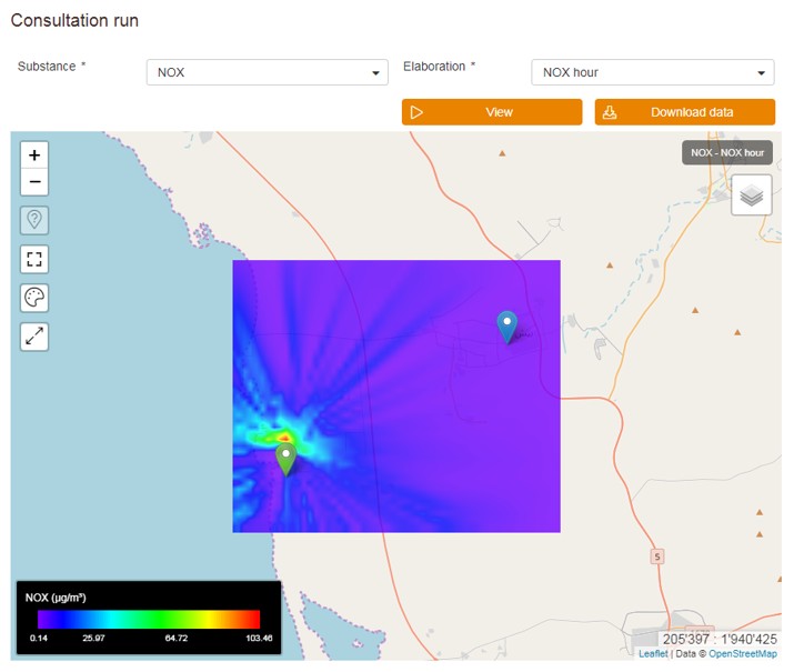
The modelling domain was configured to represent the entire Jazan region, with a grid resolution suitable for reconstructing long-range transport dynamics, air mass evolution and the combined effects of urban, traffic and industrial emissions. The use of CAMx made it possible to obtain hourly concentration fields for species such as NO₂, SO₂, CO, O₃ and fine particulate matter, as well as to provide the background concentrations necessary for more detailed analyses at smaller spatial scales.
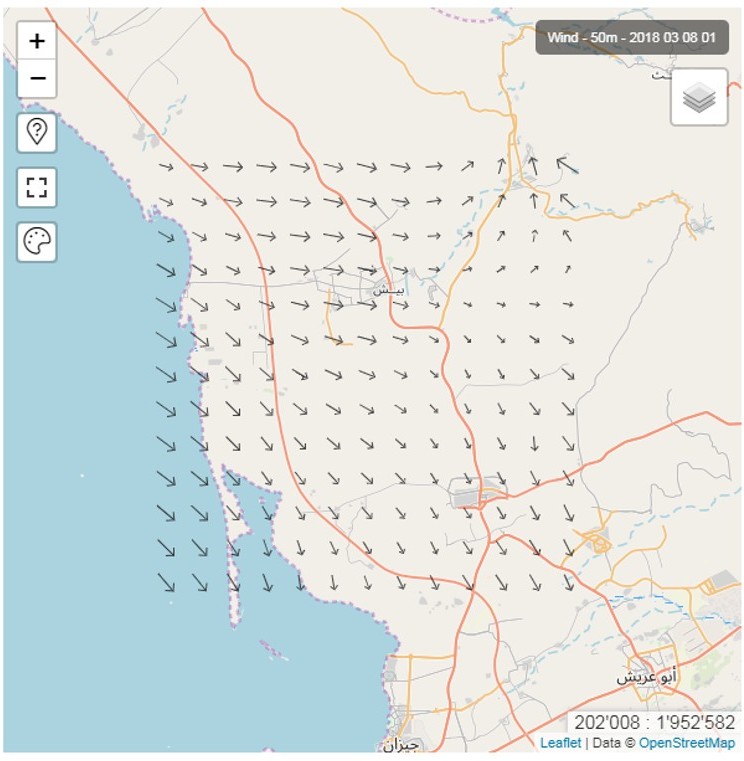
At the same time, a set of CALPUFF domains was developed to analyze the local impacts of the main point sources and the future plants included in the industrial masterplan. The non-stationary approach of CALPUFF proved particularly suitable for representing variable meteorological conditions and orographic influences typical of the area, characterized by the proximity of coastal zones, desert areas and inland reliefs. Within the local domains, the contributions of industrial emissions, energy infrastructure and transport systems were assessed through ground-level deposition maps and exposure indicators useful for the decision-making phase of the Environmental Impact Assessment.
In this context, the MARS software platform automates the WRF–CALMET–CAMx–CALPUFF workflow, standardizing outputs and providing a user-friendly console for running simulations. MARS integrates a back-end dedicated to model configuration, emission source management and meteorological field generation, together with a WebGIS front-end that enables the visualization of concentration maps, wind vector fields, receptor time series and summary reports. The platform was designed to operate both as a stand-alone solution, installed directly on the infrastructures provided in Saudi Arabia, and as a web application accessible remotely.
The modelling system developed provided an integrated representation of air quality conditions, supporting the evaluation of industrial development scenarios, verification of compliance with international standards and estimation of the potential exposure of local populations during the different phases of the project. The coordinated use of CAMx and CALPUFF made it possible to combine the broad overview of the regional scale with the granularity of the local scale, delivering a clear picture of emission contributions and the most sensitive areas.
THE ROLE OF TERRARIA
Within the project, TerrAria implemented the complete configuration of the modelling chain and developed the MARS suite, integrating CAMx and CALPUFF into a single operational, automated and user-friendly system. The activities included the definition of modelling domains, preparation of meteorological and emission datasets, optimization of simulations and design of the WebGIS interface. TerrAria also collaborated in the training of local technicians, ensuring the operational transferability of the system and guaranteeing that MARS could become a stable tool for environmental management and for the subsequent assessment phases envisaged by the international Environmental Impact Assessment.