System for water resource management
The SEGUICI project (Smart tEcnologie per la Gestione delle risorse Idriche ad Uso lrriguo e Civile – smart technologies for the management of water resources for irrigation and civil use) is part of the water resource management domain, through the development of new technological solutions aimed at optimising water use for both irrigation and civil purposes, with particular focus on reducing waste and improving the efficiency of existing distribution systems.
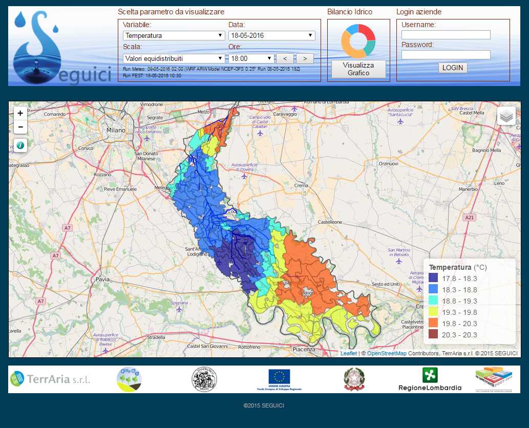
The project involves the development of an operational IT platform at the regional territorial scale, capable of collecting, processing, and organising knowledge on different water systems, integrating heterogeneous data from monitoring networks, forecasting models, and satellite observations, in order to support the implementation of regional directives through an integrated and up-to-date understanding of water resource management.
| Project: SEGUICI – Smart technologies for the management of water resources for irrigation and civil use Project Type: SMART CITIES AND COMMUNITIES of Lombardy Region – ERDF Budget: 4’110’915 Euros Duration: 2014 – 2015 Number and Partners involved: 9 project partners, all italians; CGS SpA, TerrAria srl, GESP, Politecnico di Milano – Department of Civil and Environmental Engineering, MMI, University of Milano-Bicocca, EUCENTRE, ANTARES, ORNI ENG Role: Partner |
 |
Within the framework of integrated water resource management, SEGUICI developed an advanced prototype of a Spatial Data Infrastructure (SDI), designed as a modular platform to support authorities responsible for monitoring and planning the water cycle.
The solution enables the integration, management, and enhancement of heterogeneous data related to water systems, providing a unified and dynamic view of processes. The objective is to support both operational and strategic decision-making aimed at efficient and sustainable water use, with direct benefits for aquatic ecosystem quality and the reduction of conflicts between different uses particularly those related to civil consumption and agricultural irrigation.
In the context of civil water use, the platform integrates SDI modules that enable:
- identification of leaks in pipelines;
- localisation of unauthorised water withdrawal points;
- integration of pressure and flow data for numerical modelling of water distribution networks;
- application of network analysis techniques for structural vulnerability assessment of the network, also in relation to safety and quality issues;
- application of demand forecasting techniques based on time series analysis.
In the context of irrigation water use for the agricultural sector, SEGUICI implements a system for forecasting crop water requirements based on a soil water balance model, fed by both ground-based and satellite data. The system is integrated with a medium- to long-term meteorological forecasting model.
The platform includes Spatial Data Infrastructure modules for running hydrological models that provide:
- hydrological characterisation of soils;
- acquisition and integration of data from meteorological networks;
- analysis of flow propagation within irrigation networks;
- calibration and validation using ground data and satellite imagery.
The SDI is designed to be fed by multi-source predictive data flows, including short-term weather forecasts, nowcasting techniques, and satellite data. This approach makes it possible to anticipate water demand in both civil and irrigation sectors, improving the resilience of water systems and the effectiveness of planning activities.
THE ROLE OF TERRARIA
TerrAria was responsible for implementing the irrigation module, which provides an estimation of crop water requirements through soil moisture forecasting. This is achieved by integrating a meteorological model with a hydrological model to assess the actual water needs of crops and maintain soil moisture within optimal levels for maximising agricultural production. The models are fed with ground data and satellite imagery/data both during the initialisation phase, to improve forecasting performance, and during the prediction of water demand. TerrAria developed the entire modelling chain, implemented the WRF meteorological model by configuring and validating it for the specific area of interest, and developed the Information System.