System for emergency management
The SIMULATOR project (Integrated Modular System for Risk Management and Prevention) aims to provide local Public Administrations (PAs) with an advanced Decision Support System designed to strengthen emergency management activities within a Civil Protection 2.0 framework. The project’s objective is to develop a prototype platform based on ICT (Information & Communications Technology) solutions for territorial protection and risk mitigation, with potential applications at municipal and inter-municipal scales.
The system is designed to deliver effective and tailored tools that address concrete operational needs, with the aim of safeguarding the population and the assets of the Lombardy region, including essential services, economic activities, and environmental resources. At the same time, it contributes to protecting and optimising regional infrastructure systems by enhancing the resilience and efficiency of logistics networks for the mobility of goods and people, strengthening energy and communication networks, and ensuring the continuity and reliability of production systems.
Considering the emergency management cycle, the SIMULATOR system supports Public Administrations during the phases of forecasting, prevention, management of natural and anthropogenic risks, and emergency response.
It also ensures efficient communication among different stakeholders: the Mayor, who is responsible for emergency management within their jurisdiction; operational centres (Rescue Coordination Centre, Mixed Operational Centre, Municipal Operational Centre, etc.); operational structures (Fire Brigade, Red Cross, Civil Protection volunteers, etc.) and citizens.
| Project: SIMULATOR – ModULAre Integrated System for the management and prevention of Risks Project type: BANDO SMART CITIES AND COMMUNITIES of Lombardy Region – FESR Budget: 4’112’005 Euros Duration: 2014 – 2015 Number and Partners involved: 11 project partners all italians; TerrAria srl, CNR-IDPA MiIan, Cefriel, EUCENTRE, Astir, Nier Ingegneria, Mixel, Epson Meteo – MOPI, Briantel, ESRI, BV-Tech Role: Lead Partner |
 |
The system is implemented to manage both natural and anthropogenic risks, mainly extreme meteorological and seismic events, as well as technological and chemical/industrial accidents. The SIMULATOR system consists of two main components: the CORE application, which serves as the interface for decision-makers and is developed as a web application, and the Volunteered Geographic Information (VGI) application (mobile app), which acts as the interface for Civil Protection operators and informed citizens, serving as the primary channel for collecting field information.
The SIMULATOR system operates across three phases:
- Routine: monitors the territory by collecting data from sensors and citizens, verifying threshold exceedances or potential alerts;
- Alert: supports Public Administration decision-makers with operational procedures, risk scenario analyses, and predictive simulations based on collected data;
- Emergency: provides the current scenario, possible developments, and actions to be taken, including potential evacuation plans.
THE SERVICES AND ROLE OF TERRARIA
In particular, the CORE application provides four key services for emergency management:
- a console dedicated to regulatory procedures and the steps to follow during emergencies;
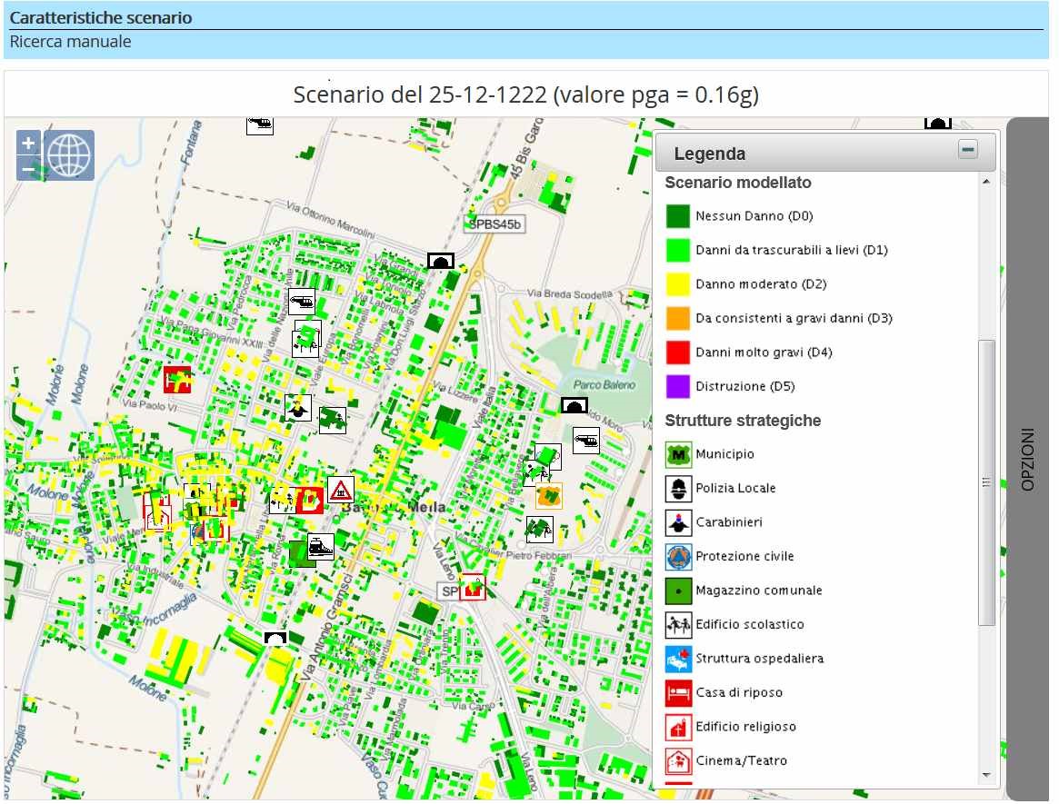
- a WebGIS that provides maps with risk areas and typical Civil Protection cartographic layers, also enabling the visualisation of key environmental variables collected through instrumental monitoring and information provided by citizens and Civil Protection volunteers – Human Sensors and VGI;
- a module dedicated to instrumental monitoring across the territory, allowing analysis of temporal trends – through graphs – of relevant sensors;
- a meteorological forecasting module covering the entire Lombardy region, enabling consultation of forecast maps for temperature and precipitation for the 72 hours following the event. SIMULATOR was tested in the municipality of Tirano (hydrogeological risk) and in the municipality of Bagnolo Mella (seismic and industrial risk), demonstrating its effectiveness in managing both natural and anthropogenic risks.
TerrAria was responsible for the overall management of the project—both technical-scientific and administrative—as well as reporting to Regione Lombardia (as project coordinator). It implemented the WebGIS module, the monitoring and weather forecasting modules of the CORE application, and also developed the ESB (Enterprise Service Bus), which enables communication among all system components.