The Advanced DSS for Civil Protection
TerrAria has designed and developed Sinergie for the Civil Protection of Regione Lombardia, an advanced Decision Support System (DSS) aimed at the integrated, real-time and forecasting management of critical issues related to hydrogeological and hydraulic natural risks.
The system evolves into the Sinergie 2.0 platform, positioning itself as an advanced digital infrastructure for risk assessment and integrated territorial monitoring, based on the synergistic processing of hydro-nivo-meteorological data, real-time radar data, and hydrological and hydraulic modelling.
The platform represents a strategic tool supporting both operators in the regional control room and territorial structures involved in monitoring, prevention, and emergency response activities. Sinergie enables a unified, timely, and in-depth view of the territory, facilitating rapid, informed, and data-driven decision-making processes.
In particular, this new evolution enables the integration of monitoring networks distributed across the Lombardy region, providing a single operational environment where observed and forecast data are correlated, analysed, and made immediately available.
Sinergie stands out for its modular and scalable architecture, capable of integrating and enhancing large volumes of heterogeneous data from multiple sources, offering advanced analysis and visualisation functionalities:
- High-frequency real-time monitoring
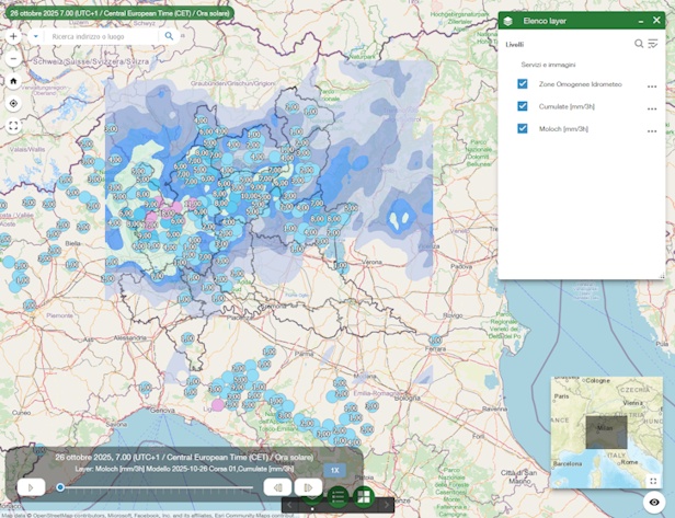
Acquisition and management of environmental data with updates down to the minute level, ensuring extremely timely insight into the evolution of phenomena and greater operational responsiveness. The platform also processes real-time meteorological radar data and distributed sensors, improving immediate detection capabilities for intense events.
- Integration of environmental monitoring data
Collection and normalisation of data from remote stations of regional ARPA agencies within the Po basin, ensuring extensive territorial coverage and data reliability. The system also aggregates data from a multi-agency network including, in addition to ARPA Lombardia, AIPo, Metropolitana Milanese, land reclamation consortia, integrated water service operators, and municipalities, ensuring an integrated and shared overview.
- Advanced automatic alerting system
Implementation of a new alerting system based on continuous monitoring of critical thresholds defined on sensor networks. The system enables:
-
- automatic detection of threshold exceedances;
- timely generation of alerts;
- support for proactive emergency management.
- Advanced analysis and geospatial visualisation
Data querying and processing through dynamic thematic maps and interactive charts, leveraging GIS functionalities and layers of the regional territorial information system.
- Real-time hydraulic risk assessment
Integrated use of specialised services for risk analysis, including:
-
- spatial representation of precipitation fields from rain gauges and radar data;
- identification of stations exceeding alert thresholds;
- correlation between observed data and criticality levels.
- These functionalities are complemented by the assessment of ground effects derived from hydrological-hydraulic modelling, a key element for predicting territorial impacts.
- Advanced forecasting modelling
Integration of advanced forecasting models with the possibility of overlaying observed real data, enabling:
-
- continuous comparison between forecast scenarios and real conditions;
- refinement of risk assessments;
- improved accuracy in operational decisions.
- The platform supports numerical simulation of natural phenomena and classification of criticality levels for each risk considered.
- Integration of meteorological models
Consultation and comparison of precipitation forecasts derived from local and European models, improving the overall reliability of analyses.
The Sinergie 2.0 platform is structured into two complementary operational macro-phases:
- Forecasting phase: analysis of meteorological data, use of numerical modelling for predicting natural phenomena, processing of ground effects, and classification of criticality levels.
- Monitoring and surveillance phase: acquisition and analysis of real-time data from environmental sensors (including rainfall, temperature, and humidity), verification of the evolution of phenomena, continuous comparison with forecasts, and dynamic updating of the risk framework.
This dual structure enables comprehensive management of the entire risk cycle: from forecasting to operational response.
Sinergie is not just a monitoring tool, but a fully-fledged advanced decision-making platform capable of:
- centralising complex information within a single operational interface;
- supporting rapid decision-making in emergency contexts;
- anticipating critical scenarios through the integration of real and forecast data;
- improving coordination among entities and operational levels;
- enabling historical and predictive analyses for proactive risk management;
- dynamically adapting to the integration of new data sources, sensors, and models.
Its architectural flexibility allows continuous system evolution, making it a key tool for addressing future challenges related to territorial management and climate change.
Access to the Sinergie 2.0 service for all interested entities is scheduled starting from June 2026.
THE ROLE OF TERRARIA
With a focus on continuous improvement and technological innovation, TerrAria has been commissioned by ARIA S.p.A. Lombardia, on behalf of Regione Lombardia, to evolve the Sinergie DSS into a new “Risk Assessment Platform.”
This evolutionary path aims to:
- enhance the system’s analytical and forecasting capabilities;
- integrate increasingly granular and real-time monitoring systems;
- evolve automatic alerting mechanisms;
- improve user experience and accessibility of information;
- strengthen the platform’s role as a central hub for integrated risk management.
Thanks to consolidated expertise in the environmental domain and in the development of complex systems, TerrAria confirms its role as a key technological partner in delivering innovative solutions to support territorial safety and civil protection.
Client: Lombardy Region
Contact person: UO Civil Protection
Year of execution: 1999 – in progres
Link: http://sinergie.protezionecivile.regione.lombardia.it