Knowledge framework on urban noise pollution in the agglomeration of Reggio Emilia
The Strategic Noise Mapping of the agglomeration of Reggio Emilia was developed to determine population exposure to noise generated by the main sources present within the municipal territory, in compliance with Legislative Decree 194/2005 and subsequent amendments and additions, applicable to urban agglomerations with more than 100’000 inhabitants. The agglomeration of Reggio Emilia territorially coincides with the Municipality of Reggio Emilia. The city is located in the central plain belt of its province: the first Apennine hills lie to the south, while the Po River area extends to the north. The agglomeration covers a territorial area of 231.6 kmq, with a resident population as of 01 January 2022 of 169’029 inhabitants (ISTAT data, 2022).
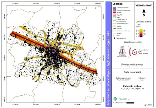
The Strategic Noise Mapping aims to develop a comprehensive knowledge framework on urban noise pollution, integrating the contribution of major and secondary road infrastructures and railway infrastructures, with particular attention to the identification of sensitive receptors (schools, hospitals, nursing homes and socio-healthcare facilities), which are more vulnerable to noise exposure, in order to support municipal health protection and environmental planning policies.
For the preparation of the Strategic Noise Mapping of the agglomeration of Reggio Emilia, the predictive software SoundPLAN was used, compliant with national and regional regulatory standards. The assessment of the acoustic climate was conducted through the estimation of acoustic descriptors, in accordance with Legislative Decree 194/2005 and the technical specifications of the Emilia-Romagna Region, so as to represent the noise generated by the different sources.
The model considers the following sound sources:
- Main roads (motorways, state and provincial roads with traffic exceeding 3 million vehicles/year), with data provided by Autostrade per l’Italia, Italian National Autonomous Roads Corporation and the Province of Reggio Emilia;
- Non-main roads, processed using data provided by the Municipality of Reggio Emilia;
- Main railway infrastructures, including the High-Speed line and the national railway network, with sound levels provided by RFI;
- Global scenario, obtained by combining road and railway contributions;
- Cartographic processing and territorial analysis.
The model enabled the calculation of noise contour levels for each environmental indicator (Lden and Lnight) and for each noise source. The results were produced in shapefile format and prepared for processing within a GIS environment, allowing the cartographic representation of the various noise contour levels for daytime and night-time periods, the spatial analysis of the areas most exposed to noise, and the estimation of resident population exposure to noise.
The integrated representation of sources highlighted the main acoustic criticalities related to noise within the urban agglomeration of Reggio Emilia, providing a homogeneous knowledge tool at municipal scale.
The results of the Strategic Noise Mapping constitute the technical basis for the definition of Noise Action Plans, aimed at reducing urban noise pollution through targeted interventions, to be assessed within the Action Plan framework, including:
- traffic management measures to reduce urban vehicle speeds;
- maintenance of road pavements;
- design of new roundabouts and traffic calming devices;
- use of noise-reducing pavements on high-traffic sections;
- intervention programmes for sensitive buildings (in particular schools);
- coordination with the managers of major road and railway infrastructures.
The project fulfilled the regulatory requirements set out in Legislative Decree 194/2005 and subsequent amendments and additions, providing the Municipality of Reggio Emilia with a technical and operational tool for planning acoustic remediation policies and the sustainable management of the urban territory.
In accordance with ministerial reporting standards, the calculated data were processed for the compilation of the Data Flows and Reporting Mechanisms required by Directive 2002/49/EC.
THE ROLE OF TERRARIA
TerrAria supported the Municipality of Reggio Emilia throughout the entire Strategic Noise Mapping process, in collaboration with an acoustic consultancy firm, analysing traffic flows, carrying out noise modelling, cartographic processing and integrating results within a GIS environment. Through the application of methodologies compliant with European standards, the company provided technical and scientific support aimed at assessing urban noise pollution and establishing a foundation for future Noise Action Plans.